Showing posts with label Lake Mead. Show all posts

November 3, 2011

Liberty Arch Bell #2 10-11-2011

Standing inside the Liberty Arch Bell
It had been over a year and half since my husband and I did this hike. (see my blog from last year May 2010) We have been hiking with groups for a while now that we decided to do this hike by ourselves. It is not hard hike at all, but rather, so pretty. And we are more physically fit (as far as hiking goes) this year so we knew this hike was a piece of cake!
We saw a family of big horn sheep. They were really close!

The difference between the first time and this time around is season. It was in May and I remember it was really hot. We didn't have all the hiking gears and gadgets that we have now,,like CamelPak. Carrying CamelPak on our back for water and everything else makes a hundred times easier than carrying heavy water bottles. 

Secondly, we made a difference by going up all the way to the Liberty Arch Bell and back side of it. Last time we took a picture having the Arch as background because it didn't look like it was climbable. This time we were more exploratory so just had to go up to see what was there!
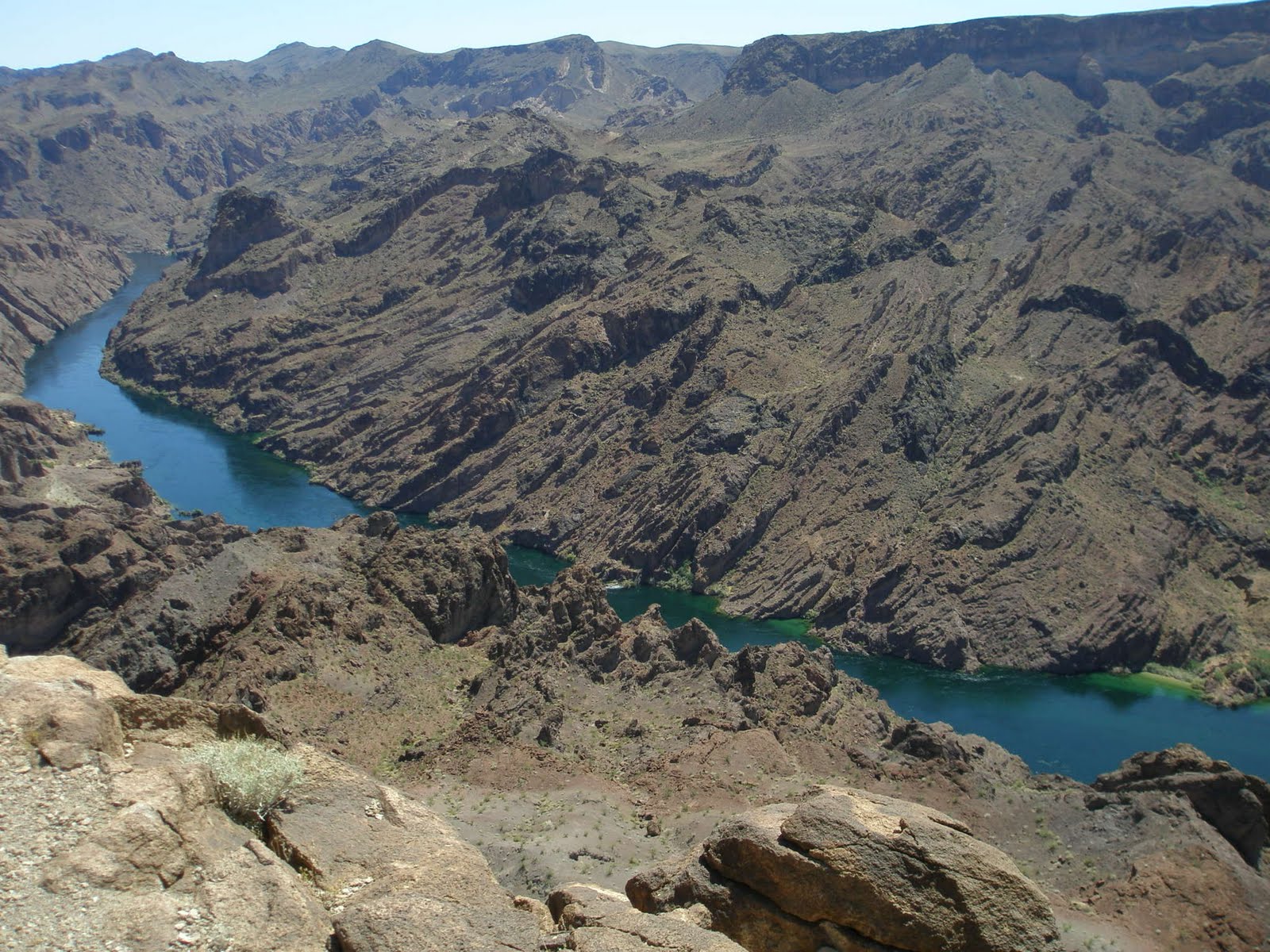
taking pic from where I stand (inside the Arch).  Hoover Dam bypass bridge is in distance
 As last time, we proceeded to the observation point for Colorado River. When you come to the Liberty Arch Bell, this spot is a MUST place to stop by. There, we had snack and took pictures! The Colorado River below seems so close but it is actually 1000 ft below us!

I love this picture below because my husband posted on the facebook titling "my wife my life" The sweetest thing to see from loving husband!
We have once mapped out where the route somehow connects to get on the Arizona Hot Spring hiking trail (see my blog). They both have a same trail head. This is on top of the hill, and the Hot Spring is down in the canyon. The theory sounds simple,, just get down the canyon. This is the third difference we made,, attempting on finding the Hot Spring trail. We derailed ourselves off of the current course and tried to find the path, but we kept getting to the dead end,, cliffs and drop offs.  Since we didn't want daylight to run out, we decided to get back to the original trail to go back to the car. Here we just created another challenge to come back to next time!


May 24, 2011

North Shore Peak 05.18.2011

4 miles loop hike, elevation gain 1,300ft (peak is 3,329ft), 3 hours hike, difficulty 2/3, class 3/5. This is located around the lake mead. After passing the fee entrance, drive to 19 mile marker area, there is a parking off to the side of the road. There is a bathroom. Nice amenity to start a hike I thought! :D


Destination is on the right mountain!

I must admit that hiking up to our destination NORTH SHORE PEAK was whole a lot easier than I thought. The trail was very gradual incline, rocks are not so loose that it was easy to maneuver around and to climb on. The foot of this mountain is full of short desert shrubs. As we walked through, we heard rattle snake! We couldn't see where it was hiding but we had to be really careful. This time of the year is neither cold or hot. It must be the best time for them to hang around. This is the 3rd rattle snakes we encountered. The last two were at the Fortification Hill hike. (I have to blog this hike.. )
This area is where I heard the rattle snake
Big step rocks but it's easy
 After going up this wall of rocks, we were on the flatter ground. Then hike up the gradual hill and there, the Peak! In 45 minutes, we were already atop. Every peak has a sign-in sheet. This place was no different.

 We take a quick group picture.

Ok. NORTH SHORE PEAK is actually the 1st peak and turned out to be the easiest part of our hiking today. There is one more peak we have to accomplish. From this point, I can see the other peak. But first we have to go down, then up, then down and up. The last "up" part is the most technical part, the knife edge.  This is how it looks to the 2nd peak.
first descend from the peak
it will get more technical at the knife edge, but not TOO bad though
closeup of rocks upon descending
standing on top of  one of the small peak
3 steps to the right is edge to the bottom
dark cloud was coming in
By the time we go to the 2nd top, we had to hurry down because the dark cloud was bringing some rain. It is not safe to be on the mountain top especially with the kind of cloud that could contain some lightening and thunder. It was a loop hike so we descended from the backside of the 2nd peak.  It was very hard going down. Very very loose rocks and the hill is so steep. I actually couldn't feel the solid ground because the rocks were piled up so thick. I was trying to hop-step-jump by finding solider rocks. Instead of mud slide, it was "ROCK SLIDE".
close up to the rock slide
bigger picture. just try not to get caught in "rock slide"
We look so small in this mountain side
So this last picture was the hillside we were trying to descend on from the 2nd peak. Can you tell how big the hill was compared to the size of human I circled? At that time we were getting some side raining. Lesson of the day: Always have wet gear such as rain jacket available in your backpack! 
 
Going downhill all the way, it lead to wash to hike through. Walking toward the road took us to the dead end. We just had to climb out of it and back to the paved road. Shortly after we were back to the parking lot!

I don't wish we get rained on all the time. But it was the first experience walking in the gloomy weather condition. It was kinda fun! Sure enough, my husband and I went to R.E.I after the trip wanting to purchase some rain jackets. We walked out the store with $300 worth of purchase, but WITHOUT the rain gear! Couldn't find the size,, too expensive,,, blah blah blah. Oh well. NEXT TIME!

April 18, 2011

Liberty Arch Bell 05.19.2010


South of Hoover Dam, there is a nice good distance hiking trail. Liberty Arch Bell. This is almost like monument. Nature force curved the dirtrock and created the shape of Liberty Bell. The trail is well distinguished and following is quite easy. The path is in the middle of flat dry land, all vegetated area with lots of short shrubs everywhere. No shade. Wrong idea to do this hike during the hottest summer. We did it in May and it was already too hot that I got a little dehydrated on the way back.

Total hiking distance is about 3 miles one way. As we moved on, we passed some kind of a carrier that was used from mining time. According to www.birdandhike.com (the site i love), it was used for magnesium mining from World War II era. Interesting! It was as if I time-traveled back to the era :-)

Moving on! Passing nothing but air and desert scenery, we find the Arch from far away!
Can you see? The finger is pointing at it. So there we go! The use-trail is getting thinner and narrower but it's clear enough to follow. Soon we were right below the arch. It is actually really big! 

Group Picture
We took couple of pictures here. Wanted to rest a little but there were no shade to rest and have lunch under. Just flat desert under the full sun. The Liberty Arch Bell is the first of two highlights of this whole hike. This Arch is located two mountain ridges away from Colorado River. After passing the Arch, the hike started to get up-hill. By following the trail up one ridge, go down and up another again, suddenly we were at the overlook of Black Canyon Colorado River! Where we stood was the ridge of 1000 ft drop off.

Black Canyon Colorado River
Woo! Scary!!!
I love his profile :-p
To me, this overlook of the canyon was the #1 highlight of the whole hike. We stayed up here for a while for lunch. I also snacked a little too much junk foods that I was not feeling well on the way back. Not so smart of me to hike in a hot weather with full stomach. Since we didn't expect the day to turn out this hot, we weren't portion-controlling our water! By the time we got back to the car, Oh my god, we were SPENT!  However, it was GREAT HIKE!  We will do it again in a heart beat, but next time, definitely before May :)

March 24, 2011

Arizona Hot Springs 02.21.2009

This is a Hot Spring hike! This time, we dragged my husband's brother to hike together. February in Las Vegas is still cold enough that hot spring is a nice treat at the end of long hike.
Arizona Hot Spring is located off of the I-95 coming from NV, passing the Hoover Dam and going into AZ. It's about 4hr, 6miles round trip hike. I recommend doing this during fall and winter. Summer can be tough. Plus who wants to dip in HOT spring during our scorching hot summer here??

Beginning of hiking
The hike started out shallow, and gradually we were walking into bigger and deeper canyon wash. It's a wash so lots of loose rock, from big boulders to tiny rocks.. They all look like volcano rocks and not river rocks.


 Walking to the hot spring is easier because the wash is about 2hr long of gradual down hill. Walking down , down , down, all the way to the side of Colorado river! The sight of water was so refreshing to see. If our ground wasn't too high, we were so tempted to jump in the water!


Now we have to turn around and keep hiking to inland back to get to the spring.  From this point on, we had to go up and down on small hills. The footing gets narrower and steeper. After we got through those section, there goes the hot spring water running down. Just hike up along the stream of water (good idea to have water shoes on because it gets really slippery), we get to the first platform. This site is right below where the hot spring is located. People change clothes here, have lunch, and/or take a rest.

Don't be afraid of height now. HERE, we have to climb up pretty much VERTICAL ladder. Don't look down !
This case, my husband's brother said he had tender feet and those radder steps were just hurting his feet big time,, well,,, so he says!?  (my husband and I don't have "tender" feet, so it was no problem!).

Talah~! We are here!!!! It kinda looks like public bath!?

1st pool
3rd pool
There are total of 3 pools. The first one is the largest but the least hottest. The second one, which I didn't post picture, is small. The third one is the hottest one because it is where the spring is coming out of the ground. The rule #1 and the most important thing when you are in natural spring is that not to dip your head in the water. Parasites can go into your body through ear, nose and mouth. It is the common knowledge everyone!


March 20, 2011

Anniversary Narrow and Peak 2.9.2010

All around the Lake Mead, there are full of hiking trails in Las Vegas. This one we went is called Anniversary Narrow and Anniversary Peak. Not sure where the names were derived from. This is one of the most PICTURE BEAUTIFUL place we've ever been. It is about 1 1/2 hr from Las Vegas.

Once we got off the Northshore road, we drove his 4x4 truck on the dirt and gravel road. We were glad that we did not take my sedan. It would have been too rough a drive, plus the car might have gotten injured :-o
Actual hike starts in the middle of the wash. We walked wide, gravel wash for 1/2 hr. This area was used for mining long ago. We saw tunnels, mining holes, left over cables, small dams and many other debris and tools to confirm those mining days.
All of a sudden, is the entrance of the Narrows! 
The narrow is a present distance. It is simply amazing how the force of water had created the shape and this narrow. We just wanted to keep taking pictures.


Through the narrow, back into the wide wash. We walked another mile or so. Here, we had to get out of the wash by taking narrower side wash as a passage that lead to another mountain edge. From here on, we had to go across the foot of mountain to get to the top. The climbing to the saddle was very steep with loose rock. All of a sudden we realized that we were in the MIDDLE OF NOWHERE! Ok, back to the quest. keep moving our butt to the top!


Anyways, once we got to the top, the saddle, we saw "BOWL OF FIRE". It was such a WOW factor view!! Unfortunately the picture doesn't give the view justice.


Get back down is easy, just go back where you came from HA'!  This whole hike may be harder if it is in summer. Pretty much whole way is in the wash, so the hike will be directly under the full sun, except the Narrows. 
Thank you for taking a journey with me today!
 

Blog Template by YummyLolly.com - Header made with PS brushes by gvalkyrie.deviantart.com
Sponsored by Free Web Space