Showing posts with label Spring Hike. Show all posts

May 24, 2011

North Shore Peak 05.18.2011

4 miles loop hike, elevation gain 1,300ft (peak is 3,329ft), 3 hours hike, difficulty 2/3, class 3/5. This is located around the lake mead. After passing the fee entrance, drive to 19 mile marker area, there is a parking off to the side of the road. There is a bathroom. Nice amenity to start a hike I thought! :D


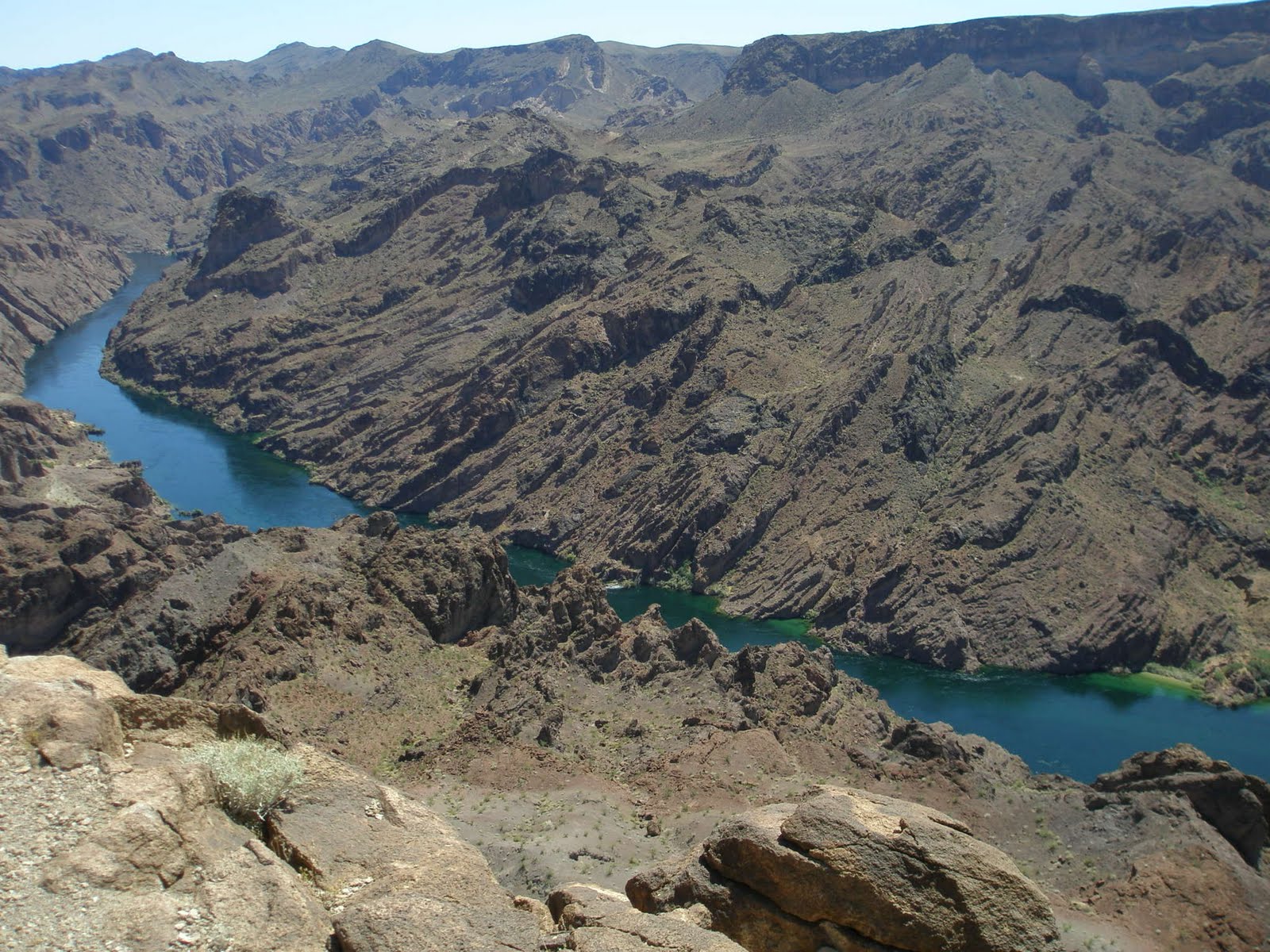
Destination is on the right mountain!

I must admit that hiking up to our destination NORTH SHORE PEAK was whole a lot easier than I thought. The trail was very gradual incline, rocks are not so loose that it was easy to maneuver around and to climb on. The foot of this mountain is full of short desert shrubs. As we walked through, we heard rattle snake! We couldn't see where it was hiding but we had to be really careful. This time of the year is neither cold or hot. It must be the best time for them to hang around. This is the 3rd rattle snakes we encountered. The last two were at the Fortification Hill hike. (I have to blog this hike.. )
This area is where I heard the rattle snake
Big step rocks but it's easy
 After going up this wall of rocks, we were on the flatter ground. Then hike up the gradual hill and there, the Peak! In 45 minutes, we were already atop. Every peak has a sign-in sheet. This place was no different.

 We take a quick group picture.

Ok. NORTH SHORE PEAK is actually the 1st peak and turned out to be the easiest part of our hiking today. There is one more peak we have to accomplish. From this point, I can see the other peak. But first we have to go down, then up, then down and up. The last "up" part is the most technical part, the knife edge.  This is how it looks to the 2nd peak.
first descend from the peak
it will get more technical at the knife edge, but not TOO bad though
closeup of rocks upon descending
standing on top of  one of the small peak
3 steps to the right is edge to the bottom
dark cloud was coming in
By the time we go to the 2nd top, we had to hurry down because the dark cloud was bringing some rain. It is not safe to be on the mountain top especially with the kind of cloud that could contain some lightening and thunder. It was a loop hike so we descended from the backside of the 2nd peak.  It was very hard going down. Very very loose rocks and the hill is so steep. I actually couldn't feel the solid ground because the rocks were piled up so thick. I was trying to hop-step-jump by finding solider rocks. Instead of mud slide, it was "ROCK SLIDE".
close up to the rock slide
bigger picture. just try not to get caught in "rock slide"
We look so small in this mountain side
So this last picture was the hillside we were trying to descend on from the 2nd peak. Can you tell how big the hill was compared to the size of human I circled? At that time we were getting some side raining. Lesson of the day: Always have wet gear such as rain jacket available in your backpack! 
 
Going downhill all the way, it lead to wash to hike through. Walking toward the road took us to the dead end. We just had to climb out of it and back to the paved road. Shortly after we were back to the parking lot!

I don't wish we get rained on all the time. But it was the first experience walking in the gloomy weather condition. It was kinda fun! Sure enough, my husband and I went to R.E.I after the trip wanting to purchase some rain jackets. We walked out the store with $300 worth of purchase, but WITHOUT the rain gear! Couldn't find the size,, too expensive,,, blah blah blah. Oh well. NEXT TIME!

May 10, 2011

North Peak via the north peak wash 05.03.2011

Let me tell you this. GETTING to the trail head was the worst experience for me!!! The hike is inside the redrock loop, passing the lost creek and picnic area. The dirt road will have a turnoff to the right to La Madre Springs, but we keep going straight. The road gets narrower and bumpier! Here, HC (high clearance vehicle) is required and definitely 4x4 if we had to keep driving to where we did! We were driving 4x4 dodge truck. This truck is TOO BIG for this road! Anyways, I was scared to death as if the car was gonna tip over or something. 

It took us about 45min from the entrance of Redrock to the North Peak trail head. 

This is a hike to North Peak by climbing wash in the back of the mountain. When you say "wash" you think of big boulders laying around and hike up by maneuvering them. Well yeah, we started off doing that, but at one point, that was over. And after that it seemed that we were climbing on one big rock straight up for like 1 1/2 hour. STRAIGHT UP! The hiking description said that this peak is the 2nd highest in Redrock and that we would gain 1300 ft in less than 1100 yard!
The steepness goes on for a while
view as we climb the wash

Just climb climb climb. I was on hands and knees on most parts that I felt as if I were a spider. Good hiking shoes required! Good grip of the hiking boots helped me without slipping.

The view from the top was stunning. I had never seen the view from this side of the park. This peak being the 2nd highest sure makes it a great scenery.
Not a single cloud!
Hi Cheeze!
On the way back, we took a different trail down. And we found this interesting picnic site. Obviously someone? or group of people? have built this.  It is well built by the way.
This is a flat top of the mountain. Whoever built this, found the good spot! We walked around the area to check it out before further descending. Don't wanna be playing or getting too close to the edge because..

This is how it looks below the edge line. I had to extend my short arm to take this picture. Scaarry~
Descending on loose rocks was certainly tough part. It puts so much strain on knees and feet. I can see why people with bad knees really have hard time descending when no problem ascending.
All in all, it was very fitness hike.  Definite alternate to gym day.

April 27, 2011

Calico Tank Peak 04.20.2011

Calico Tank Peak. It is located before going into the visitor center entrance of Red Rock Canyon. This is the very first hiking with Meetup that includes some SCRAMBLING AND EXPOSURE that we had never experienced before! On this day, my husband and I also joined the hiking club called "52 Peak Club". It is a club to achieve all 52 peaks in Las Vegas, mainly located around at Red Rock, Lake Mead and Mt. Charleston. There are some very competitive hikers among the group. And I am so excited to get to hike with them. Anyways, this hike was about 4 hours round trip, requires class 3 scrambling.

Starting at the foot of the peak, already the ground is not flat
Gets steeper, good shoes are really important
Within 1/2 hour, we were already on the bare wall of the mountain. The incline is steep that good hiking shoes with solid grip really come in handy. On this particular wall of mountain, we still did not need to use hands much. Our body keeps the balance against the steep footing.

Already good view from mid point to the peak
 Every once in a while, after steep scrambling, we got to the flatter ground and took break. Then off to more scrambling on vertical wall and edge of the mountain....

Just have to hold on to tiny edges where shoe can fit in...

Trying to find every little crevasses...

Nice pic! We look like rock climber without rope! Wow!
 I had this cheap winter gloves I got from Target. It doesn't work for this kind of hiking! My hands were slipping and couldn't get good grip. So I took them off. The bare hands seemed to work better. But I need to invest on hiking gloves. Even some type of gardening gloves can give you good grips, so I was told. So I'm gonna have to check it out in the store one of these days. My husband seemed to be nervous for me. He always thinks I am clumsy. He knows that I can't be clumsy on the edge of the mountain. No mistake allowed. Because of that reason, he looks nervous when we do this kind of hike (the kind with potential danger). I don't blame him. He loves me!

Anyhow, we are almost to the top. Do you see the red rock changes to the white rock at the top? That's the peak!


almost there.....
 Wah Laahh~!! The PEAK! The feeling of accomplishment is greater this time because of the facts that this was a challenging hike for both of us and that we kept up with some experienced hikers! The advantage I have is that I don't weigh much so it was easier to use my upper body strength to life myself up. My disadvantage is that I have shorter legs which can make thing tougher on some parts of the trail, jumping on big gaps and/or taking big steps on the vertical wall.
All in all, with the help of others, We did it!!

from the left, my hub, me, Marisa,Ted, Gary, Skip, Jack, Patrick and Mj!
 This hike gave us more confidence in our skills on hiking experiences!!


April 18, 2011

Liberty Arch Bell 05.19.2010


South of Hoover Dam, there is a nice good distance hiking trail. Liberty Arch Bell. This is almost like monument. Nature force curved the dirtrock and created the shape of Liberty Bell. The trail is well distinguished and following is quite easy. The path is in the middle of flat dry land, all vegetated area with lots of short shrubs everywhere. No shade. Wrong idea to do this hike during the hottest summer. We did it in May and it was already too hot that I got a little dehydrated on the way back.

Total hiking distance is about 3 miles one way. As we moved on, we passed some kind of a carrier that was used from mining time. According to www.birdandhike.com (the site i love), it was used for magnesium mining from World War II era. Interesting! It was as if I time-traveled back to the era :-)

Moving on! Passing nothing but air and desert scenery, we find the Arch from far away!
Can you see? The finger is pointing at it. So there we go! The use-trail is getting thinner and narrower but it's clear enough to follow. Soon we were right below the arch. It is actually really big! 

Group Picture
We took couple of pictures here. Wanted to rest a little but there were no shade to rest and have lunch under. Just flat desert under the full sun. The Liberty Arch Bell is the first of two highlights of this whole hike. This Arch is located two mountain ridges away from Colorado River. After passing the Arch, the hike started to get up-hill. By following the trail up one ridge, go down and up another again, suddenly we were at the overlook of Black Canyon Colorado River! Where we stood was the ridge of 1000 ft drop off.

Black Canyon Colorado River
Woo! Scary!!!
I love his profile :-p
To me, this overlook of the canyon was the #1 highlight of the whole hike. We stayed up here for a while for lunch. I also snacked a little too much junk foods that I was not feeling well on the way back. Not so smart of me to hike in a hot weather with full stomach. Since we didn't expect the day to turn out this hot, we weren't portion-controlling our water! By the time we got back to the car, Oh my god, we were SPENT!  However, it was GREAT HIKE!  We will do it again in a heart beat, but next time, definitely before May :)


Blog Template by YummyLolly.com - Header made with PS brushes by gvalkyrie.deviantart.com
Sponsored by Free Web Space